


The new museum of Forma Urbis in Rome
from Nikolas Möller
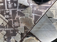
Ancient Rome can be explored in many different ways. A new option has been available since mid-January 2024 at the Museo della Forma Urbis in the Parco archeologico del Celio. The "Forma urbis" is a unique, albeit unfortunately only partially preserved, graphic representation of the city of Rome. Although fragmented, it is nevertheless an important testimony to the topography of the city and its reconstruction.
This "city map" was produced at the beginning of the 3rd century AD during the reign of Emperor Septimius Severus. It consisted of 150 marble slabs, measured around 18 x 13 metres and was originally hung on a wall in the "Templum Pacis". The wall still exists today and is the clearly visible outer wall of the church of SS. Cosma e Damiano at the Forum Romanum. You can still see the mounting holes in the wall for the plates of the map.
In the newly opened museum, the clearly identifiable pieces (around 200) are now embedded in the floor of a large city map of Rome (Giovanni Battista Nolli, 1748). This makes them much more accessible for viewing, as visitors familiar with the city can easily orientate themselves and "hike" the "Forma urbis", so to speak. Display boards with plans and further information, for example on the plan legend and spelling mistakes in the inscriptions, round off the exhibition.
It is very pleasing that this important testimony to the topography of Rome has been made accessible to the public again in a didactically appealing way. However, as only around 10% of the plan has been preserved, one should not be disappointed that many areas are missing. However, it can never be ruled out that further parts will be found and that the fragments that have not yet been categorised will find their correct place.
At this point, the digital Forma urbis project of Stanford University should be mentioned.
The museum is open from Tuesday to Sunday from 10:00 to 16:00 (last admission one hour before). It is closed on 25 December, 1 May and Mondays.
- Details
- Written by: Stefan Heid
- Category: Roman notes